




Go Track Free

Go Track Free açıklaması
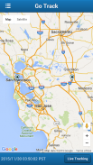
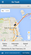
Go Track is mobile client for OpenGTS open source project. It is designed to view last GPS position of the devices configured in OpenGTS and also view the trail of the device in map.
Go Track app is designed to show the standard icons comes with default OpenGTS server. Customer who have customized PushPin Icons in OpenGTS server, will not be view their customized PushPin Icons in Go Track app. The customized icons will be shown as black icons.
We have developed www.GoTracky.com for customers to easily rebrand GoTrack app based on Company Name, Logo and Color Theme. Also, the rebranded app will be able to integrate customized PushPin Icons in customer's OpenGTS server.
OpenGTS™ ("Open GPS Tracking System") is the first available open source project designed specifically to provide web-based GPS tracking services for a "fleet" of vehicles (http://www.opengts.org).
This FREE version is ad supported and limitation of viewing 3 vehicles. Free rebranded app via www.GoTracky.com shows all devices.
Features:
- View vheicles configured in OpenGTS.
- View most recent position of the vehicle in Map.
- View all vehicles and last position in Map.
- Search for vehicle track based on date.
- Manual and auto update of vehicle position and track (update every 1 minute)
Configuration:
- In settings page, configure the OpenGTS server URL.
http://www.mydomain.com/track/
- Set track.enableAuthenticationService to true in private.xml.
Version 4.4
- Changed Google Map to Openstreet Map
- Issues fixed
Version 4.3
New Features and Issued fixed:
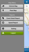
- Two new reports added - Event Detail and Speed Report
- Refresh device list when changing account, i.e. logout and login with another account.
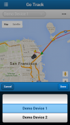
- Option to search for Device in Device List
- In Settings, OpenGTS URL will be defaulted to http://, to facilitate faster entry.
Version 4.0
1. Fixes to work with latest version of OpenGTS.
New Features:
1. Sliding Menu for easy navigation.
2. Vehicle Latest location information such as Address, Speed, Odometer and Status (such as Start, InMotion or stop) is shown in Vehicle Map.
3. Locate feature in Vehicle Map to display the users current location.
4. When a vehicle is lost, Vehicle Latest location information, Live Tracking and Locate feature in Vehicle Map is useful to track and follow the vehicle based on user's current location.
Reports Enhancements:
1. Report display is optimized for easy viewing of report details.
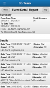
2. Event Detail Report show summary such as Total distance travelled (based on Odometer), from and to address.
3. Event Detail Report information can be viewed on Map.
Version 3.2
Issues Fixed in this version:
- App not working in Android 4.x
- Apps crashes when physically turning the mobile from portrait to landscape (or the other way around)
- Search result will remove the existing track on the map.
- Marker bubble: clicking on new bubble will remove the old bubble. Also, the bubble will automatically removed after 30 seconds.
Version 3.1
Issues Fixed:
- Data persistence issue (entering OpenGTS URL every time to run the apps)
New Features:
- In vehicle list, added last event address and date time.
- In Group Map, auto zoom to show all the vehicles.
- In Settings following options will be added:
- Limit no of data points in Vehicle Map.
- Show/hide the markers in Vehicle Map.
- Show/hide the route arrow in Vehicle Map.
Version 3.0
Fixed the problem with Login Failure issue.
Version 2.0
Removed the Camera permission.
Go Track, OpenGTS açık kaynak projesi için mobil istemcidir. OpenGTS'de yapılandırılan cihazların son GPS konumunu görmek ve aynı zamanda cihazın izini harita içinde görüntülemek için tasarlanmıştır.
Go Track uygulaması standart ikonların varsayılan OpenGTS sunucusu ile gelmesini göstermek için tasarlanmıştır. OpenGTS sunucusunda PushPin Simgelerini özelleştiren müşteri, Go Track uygulamasında kendi özelleştirilmiş PushPin Simgelerini görmeyecektir. Özel simgeler siyah simgeler olarak gösterilecektir.
Müşterilerimiz için, GoTrack uygulamasını Şirket Adı, Logo ve Renk Teması'na göre kolayca yeniden pazarlamak için www.GoTracky.com'u geliştirdik. Ayrıca, yeniden adlandırılan uygulama müşterinin OpenGTS sunucusunda özelleştirilmiş PushPin Simgelerini entegre edebilecektir.
OpenGTS ™ ("Açık GPS Takip Sistemi"), özellikle bir "filo" aracı için web tabanlı GPS izleme hizmetleri sağlamak üzere tasarlanmış ilk açık kaynak kodlu projedir (http://www.opengts.org).
Bu ÜCRETSİZ sürümü reklam destekli ve 3 araç görüntüleme sınırlaması. Www.GoTracky.com üzerinden ücretsiz yeniden pazarlanan uygulama tüm cihazları gösterir.
Özellikler:
- OpenGTS'de yapılandırılmış vheikülleri görüntüleyin.
- Aracın haritadaki en son konumunu görün.
- Haritadaki tüm araçları ve son konumu görüntüleyin.
- Tarihe göre araç parça ara.
- Araç pozisyonu ve paletinin manuel ve otomatik güncellemesi (her 1 dakikada bir güncellenir)
Yapılandırma:
- Ayarlar sayfasında OpenGTS sunucu URL'sini yapılandırın.
http://www.mydomain.com/track/
- private.xml dosyasında track.enableAuthenticationService öğesini true olarak ayarlayın.
Sürüm 4.4
- Google Map’i Openstreet Haritasına Değiştirdi
- Sorun giderildi
Sürüm 4.3
Yeni Özellikler ve Verilen sabit:
- İki yeni rapor eklendi - Etkinlik Detayı ve Hız Raporu
- Hesap değiştirirken, örneğin oturumu kapatıp başka bir hesapla giriş yaparken cihaz listesini yenileyin.
- Cihaz Listesinde Cihaz aramak için Seçenek
- Ayarlar'da, daha hızlı girişi kolaylaştırmak için OpenGTS URL'si varsayılan olarak http: // olarak ayarlanacaktır.
Sürüm 4.0
1. OpenGTS'nin son sürümü ile çalışmak için düzeltmeler.
Yeni özellikler:
Kolay gezinme için 1. Kayar Menü.
2. Araç Adres, Hız, Kilometre Sayacı ve Durum gibi son konum bilgileri (Start, InMotion veya stop gibi) Araç Haritasında gösterilir.
3. Kullanıcıların mevcut konumunu görüntülemek için Araç Haritasındaki özelliği bulun.
4. Bir araç kaybolduğunda, Araç Haritasındaki Araç Son konum bilgisi, Canlı İzleme ve Bulma özelliği, kullanıcının o anki konumuna göre aracı takip etmek ve takip etmek için kullanışlıdır.
Rapor Geliştirmeleri:
1. Rapor ekranı rapor ayrıntılarının kolayca görüntülenmesi için optimize edilmiştir.
2. Olay Detay Raporu, seyahat edilen toplam mesafe (Kilometre Sayacına dayalı) ve adrese kadar olan toplamı gösterir.
3. Etkinlik Ayrıntı Raporu bilgileri Harita üzerinde görüntülenebilir.
3.2 Sürümü
Bu sürümde düzeltilen sorunlar:
- Uygulama Android 4.x'de çalışmıyor
- Mobil cihazları mobilden dikey olarak yatay duruma getirirken (veya diğer yollarla) uygulamalar çöküyor
- Arama sonucu haritadaki mevcut parçayı kaldıracaktır.
- Marker balonu: yeni balonu tıklamak eski balonu kaldırır. Ayrıca, balon 30 saniye sonra otomatik olarak kaldırılacaktır.
Sürüm 3.1
Sorunlar giderildi:
- Veri kalıcılık sorunu (uygulamaları çalıştırmak için her seferinde OpenGTS URL'sini girme)
Yeni özellikler:
- Araç listesinde son etkinlik adresini ve tarih saatini eklediniz.
- Grup Haritası'nda, tüm araçları göstermek için otomatik zoom.
- Ayarlarda aşağıdaki seçenekler eklenecektir:
- Araç Haritasındaki hiçbir veri noktasını sınırlandırın.
- Araç Haritasındaki işaretleyicileri göster / gizle.
- Araç Haritasındaki rota oku göster / gizle.
Sürüm 3.0
Oturum açma hatası sorunu ile ilgili sorunu düzeltildi.
Sürüm 2.0
Kamera iznini kaldırdı.


